Share Rezoning of 61 Waverly Street on FacebookShare Rezoning of 61 Waverly Street on TwitterShare Rezoning of 61 Waverly Street on LinkedinEmail Rezoning of 61 Waverly Street link
An applicant has submitted a proposal to the Town's Planning Department to rezone the subject property, 61 Waverly Street (refer to image), from its current zoning of a Commercial-Industrial (CI-4) Zone to a Medium Density Residential (R-2) Zone. A "zone" can be best described as regulating what a person is able to do on their property in terms of development. The Town's Land Use By-law Zoning Map designates zones for each parcel within the Town of Yarmouth and the Land Use By-law outlines specific development restrictions for each zone. The Town of Yarmouth Zoning Map and Land Use By-law areContinue reading
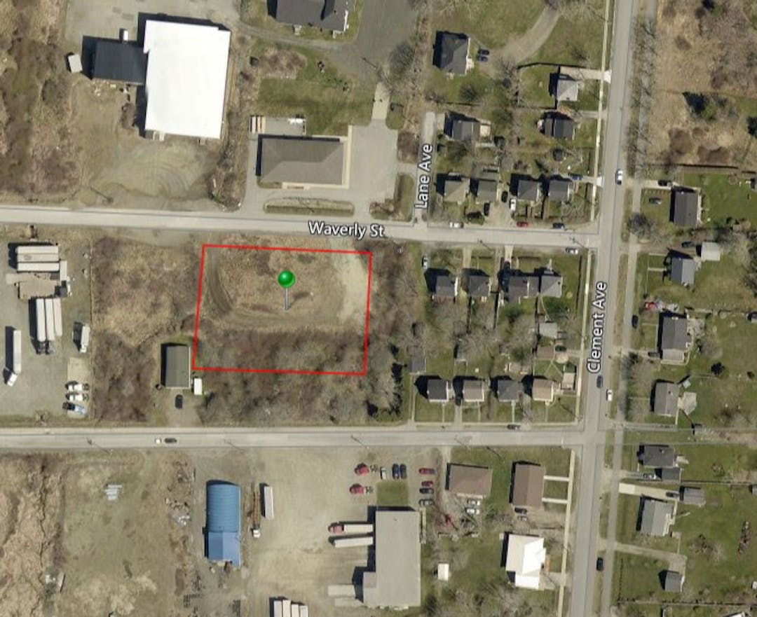
An applicant has submitted a proposal to the Town's Planning Department to rezone the subject property, 61 Waverly Street (refer to image), from its current zoning of a Commercial-Industrial (CI-4) Zone to a Medium Density Residential (R-2) Zone. A "zone" can be best described as regulating what a person is able to do on their property in terms of development. The Town's Land Use By-law Zoning Map designates zones for each parcel within the Town of Yarmouth and the Land Use By-law outlines specific development restrictions for each zone. The Town of Yarmouth Zoning Map and Land Use By-law are provided to the right of this page under the "Documents" heading for more information about zoning or about the Commercial-Industrial (CI-4) and Medium Density Residential (R-2) Zones.
Rezoning of the subject property to a Medium Density Residential (R-2) Zone would permit a maximum of one (1) of the following uses, as outlined in the Town of Yarmouth Land Use By-law:
All Low Density Residential (R-1) Zone uses, subject to all R-1 zoning requirements, which are the following:
Single Detached Dwellings (single-family dwellings).
A residential building consisting of a maximum of two (2) dwelling units.
Semi-detached Dwellings consisting of not more than one (1) shared property line with a maximum of one (1) residential dwelling unit per lot.
Semi-detached Dwellings that do not share more than one (1) property line with a maximum of two (2) units per lot; and
A residential building or group dwellings that consist of a total of anywhere between three (3) to six (6) dwelling units.
The applicant is interested in placing a single-family dwelling on the property. Approving the applicant's proposal would require an amendment to the Generalized Future Land Use Map within the Town of Yarmouth's Municipal Planning Strategy. The purpose of a Generalized Future Land Use Map is to designate areas of the Town for potential future development based on their current use and zoning. Amendments to this map would involve re-designating the subject property from Commercial-Industrial to Residential. The Generalized Future Land Use Map is also attached to this page under the "Documents" heading, indicated on the right. In addition, amendments are also necessary to the Zoning Map of the Town of Yarmouth Land Use By-law in order to rezone the subject property from Commercial-Industrial (CI-4) to Medium Density Residential (R-2).
Any amendments to the Municipal Planning Strategy are first required to undergo a Public Participation Meeting with the Planning Advisory Committee as part of the approval process. At this meeting, anyone from Public is able attend and express their concerns or thoughts about the proposal. The Public Participation Meeting will be held on Tuesday, April 6th, 2021, at 7pm. Anyone from the Public that is interested in participating at the Meeting is required to register, either to speak or submit a written submission to the Planning Advisory Committee, by contacting the Town of Yarmouth Planning Department through the following email: planningadmin@townofyarmouth.ca or calling (902) 742-1505 ext. 236. The Public Participation Meeting will be held virtually and once registered, an email will be sent to you with a link to the Meeting.
A survey is also provided below with a list of questions about the proposal for anyone to respond to. All results from the respondents of the survey will be recorded and provided to the Planning Advisory Committee at the Public Participation Meeting. These results will be taken into consideration by the Planning Advisory Committee when making their decision to either reject or approve the proposal to bring to Council for First Reading.
More information about the proposal can be found by reading the Planner's report on the Development Applications page of the Town of Yarmouth website: https://www.townofyarmouth.ca/current-applications.html. The Planner's report is also attached to this page as shown to the right under the "Documents" heading.
Site Context:
Aerial image of the subject property, 61 Waverly Street, indicated by the green pin, and the surrounding neighbourhood.
Share Public Survey for Applicant Proposal: 61 Waverly Street. on FacebookShare Public Survey for Applicant Proposal: 61 Waverly Street. on TwitterShare Public Survey for Applicant Proposal: 61 Waverly Street. on LinkedinEmail Public Survey for Applicant Proposal: 61 Waverly Street. link
Page last updated: 11 Aug 2021, 10:15 AM
Application Approval Process:
Planning Advisory Committee (PAC) Meeting
Rezoning of 61 Waverly Street has finished this stage
Tuesday, March 2nd, 2021, at 7 pm.
Public Participation Meeting
Rezoning of 61 Waverly Street has finished this stage
Tuesday, April 6th, 2021, at 7 pm.
Council (First Reading)
Rezoning of 61 Waverly Street has finished this stage
Thursday, April 8th, 2021, at 7:30 pm.
Council (Public Hearing)
Rezoning of 61 Waverly Street has finished this stage